

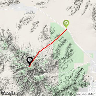
32.4
PDI
17.3 mi
DISTANCE
5,371 ft
GAINED
5.9 %
AVG. GRADE
FULL CLIMB STATS
Page Contributor(s): Ron Hawks, Las Vegas, Nevada, U.S.A
INTRO
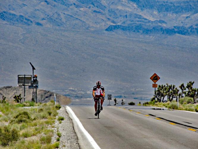
"One of the most difficult hill climbs in the United States and perhaps the most difficult in the state of Nevada, Lee Canyon (Route 156) pulls away from Highway 95 within a wide, desert valley on a very straight and steady grade road toward massive Mount Charleston. Wide open, the straight routing makes for efficient travel but unfortunately also lets you see much of the agony to come (and can be quite hot in the warmer half of the year).
The hill has a shallow to moderate start but soon becomes very steady grade as you head higher, passing through mesquite and cactus patches along the way. As you ride west the grade remains fairly steady and you will also pass major altitude signs at intervals..." (This quote is presented with the approval of John Summerson, from his book, The Complete Guide to Climbing (by Bike), 2nd Edition, pg. 196.)
PLAN YOUR ROUTE
PROFILE CLICK IMAGE or BUTTON FOR INTERACTIVE TOOL

The average grade on this climb is 5.9%. 25% (4.3 miles) is at 0-5% and 74% (12.8 miles) is at 5-10%. The steepest quarter-mile is 8.4% and steepest continuous mile 7.3%.
See more details and tools regarding this climb's grade via the “Profile Tool” button.
Roadway: Excellent.
Traffic: Mild but travelling at highway speeds of 55-60 mph. The climb is to a dead end so there are not a lot of commercial trucks on the road.
Parking: At climb start - Map; Street View.
Provisions: None on the route.
Weather: This climb is in the Mojave Desert and the average high for June-August is 99-104. Additionally, you finish the climb nearly 5,000' above your starting altitude. Therefore, be sure to consult the PJAMM "Full Forecast" feature for the time you expect to arrive at climb start and finish to assess what clothing to bring on your ride.
Before heading out on any cycling adventure check out our Things to Bring on a Cycling Trip and use our interactive check list to ensure you don't forget anything.
Also consider climbing Kyle Canyon as part of your cycling day. You can cut across to Kyle Canyon, Highway 157 via Highway 158, at the 14 mile mark of this climb (or 3.3 miles back down from the finish).
We stayed in Las Vegas when we did these climbs and drove the 18 miles from Vegas to this climb for our long riding day.
ROUTE MAP
MEMBER RATING
CURRENT WEATHER
PJAMM TRIPS ADVENTURE STARTER BUNDLES
Check out PJAMM Adventure's prepackaged (self-guided) cycling trips. They will help you plan, document and conquer your next adventure.
NEARBY CLIMBS (0) RADIAL PROXIMITY
FROM No Climbs Found
MEMBER REVIEWS & COMMENTS
Let us know what you thought of this climb. Signup for our FREE membership to write a review or post a comment.
Already have an account?
LOG IN HERE
Gtmandan

Pretty good climb for 17 miles. It wasn’t overly challenging but was sustained grade throughout the ride. It’s pretty darn straight up the mountain and the road conditions were excellent. The traffic was moderate but there were several cars that buzz us even though the opposite lane was clear. A bit unnerving with this but also the speed limit for the majority of the ride is 55MPH and trucks would go higher than that. There’s a nice coffee shop on top but there are no provisions on the route until then. The ride downhill was pretty awesome in which no pedaling for 17 miles.
handcycle
I've done Mt. Evans, but Lee Canyon felt more difficult due to the monotony. No shade, no flats, no turns, and the desert looks the same for much of the ride. Just straight and straight up. It's as much of a mental challenge as physical. The sun was brutal even in April; wear long sleeves, bring plenty of water and sunscreen. Easy parking at the base.
trier1992
Great and easily accessible climb. I parked right at the bottom of the canyon across the road in a gravel lot. In mid October, traffic was light, but temperatures at the peak were very cold. Gorgeous dessert views for 80% of the climb, while the last 20% were far more alpine and woodsy.
jsummers
A big climb, likely the most difficult in NV but the steady grade can help (no grade surprises on this one). There is now a traffic circle near the top and the road dead ends within high mountain scenery. You may want to avoid in summer and the descent is quite amazing.


